The Interactive GIS Application (app) for the UCR Botanic Gardens has been officially released to the public! We have utilized Esri Enterprise ArcGIS Online, so the “power of where” can be integrated into the project. To make this app user friendly, we want to provide a few tips on how to navigate your way through it. The application can be loaded on your smart phone to view your location in the Gardens. The 3” aerial imagery will allow you to navigate to almost any point and locate a selected specimen. The app can also be used on desktop computers and tablets when you aren’t physically in the Gardens. Click on the URL or the button to get started:
https://ucr.maps.arcgis.com/apps/webappviewer/index.html?id=36bf2fdff28f4339988321700f82f071
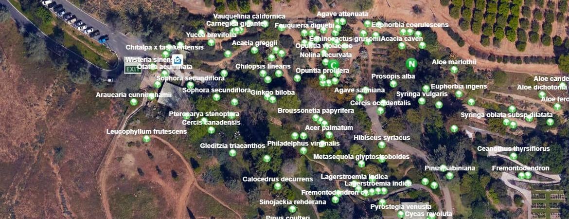
The Splash Screen will always pop up before the GIS application loads. The upper section of the Splash screen shows tips on using the app, and the lower section contains legal information on limitations of the data and how it should be used. You can also check out the “W” Welcome icon for current information and other useful links. Once you review and agree to the terms and conditions, press Go to enter the app. The map will open to an aerial view of the whole UCR Botanic Gardens. On the bottom of the screen are handy tools.
From left to right you will find:
- Layer icon - You can turn layers off and on as needed in your session. They will come back by default when you reload the app
- About icon - Currently has our contact information
- Ruler icon - To measure distances on the map
- Print icon – To print a screen shot
- Filter icon - A powerful tool to rapidly update the display with just what you want to see. You can filter on genus, common name, family, or accession #.
On the left side of the screen there are four icons:
- Plus & minus - For zooming in or out, or you can use your mouse on your computer or your finger on a mobile device
- Home – For bringing you back to the original home screen
- My location – This will bring you to your location and a blue dot will appear.
Only use this feature if you are in the Botanic Gardens. To locate a particular plant, you can zoom in on the home screen and the Latin names of the plants will appear. If you only know the common name or a portion of it you can use the search function at the top of the screen, which can search by common name, Latin name, family, or accession number. Just type in what you know and a list will drop down with every plant containing those letters. When you click on the plant you want the app will bring you to that plant and a pop-up window will appear. Use the arrows on either side of the picture to scroll through the photos and click on a photo to enlarge it.
When you are in the Gardens click on the location button to locate where you are. If you have good coverage from your cell service provider you will enjoy the interactive features on your phone. You will be able to see your location on the phone and see what’s all around you. You can then click on features on the screen to get the pop-up window with pictures and details about that specimen you are looking at. For some of our thematic and geographic gardens we have included virtual reality imagery in full 360° grandeur that will compel you to visit! Currently there are 360° photos of the desert section, CA North Coast, Butterfly Garden, and Bobcat Rocks. We currently have 156 specimens on the map and will continue to add more as time permits, as well as more 360° photos. We are also working on adding a layer with all the Botanic Gardens memorials. We sincerely hope this interactive app will enhance your Gardens experience!

GIS Map QR code
Let us help you with your search